Keywords: Open Source Technologies, Map
•Today, the population of Bamako is estimated to be around 5,000,000, including the surrounding metropolitan area. In terms of urban sprawl-driven growth, the city is the largest in Africa and sixth in the world. The project is titled "Geportail de Bamako" and will be renamed "Bamakokunafoni" in its scaling up, providing information about Bamako in the local Bambara language. Because of limited financial resources and technical services facing human resource deficits, complex software requiring licenses is not a viable and sustainable option. Hence, the choice was made to adopt a collaborative model based on volunteers. Recognizing these realities, a system based on open-source applications was developed, especially one that allowed for updates through smartphones.
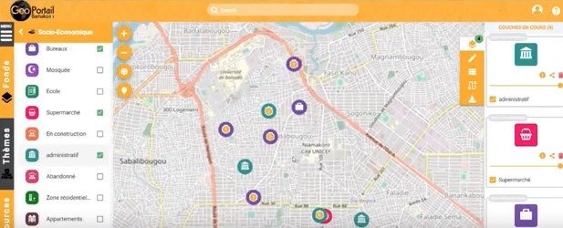
The model is based on the methodology of the OpenstreetMap Mali (OSM) local government and young volunteer interns. It relies on a collaborative map that is accessible online and does not require specific training. The OSM local government consists of dynamic young individuals. The interactive online mapping tool emphasizes priority basic social services. It allows citizens to access information about basic social facilities covered, and it enables elected officials to have decision-making support elements and a 360-degree view of their territorial network. In the future, citizens will be able to contribute data. This tool has revealed the territory; Its Objectives are: to provide practical decision support information about basic social facilities; to make real-time information available to citizens and urban professionals and to ensure open access to data with the possibility for urban stakeholders to contribute to the database..